Mexican Texas or Texan Mexico

Visit this fantastic map of Mexican Texas in 1835 (mislabeled as Republic of Texas) in the Barry Ruderman collection, https://www.raremaps.com/gallery/detail/64186/texas-republic-of-texas-bradford

Late last week, a reader asked me if the Red River had ever served as a boundary between the United States and Mexico prior to Texas becoming a Republic in 1836

Between 1803 (when the U.S. purchased the Louisiana Territory) and 1819 (before Mexico became its own republic), the Red River was the border between New Spain and the United States north of the Great Raft… kind of. Filibustering Anglos and Native people who were forcefully displaced by the United States populated the Red River area above the Great Raft and down the Sabine River. The absence of troops, abandonment of forts, and the lack of good surveys marked the region essentially a “no man’s land.”
This all had to do with the fact that the Red River emptied into the Mississippi River, the southern-most major river to do so. It promised to become an important trade route, with the assumption that it could carry goods from New Orleans all the way to Santa Fe. Since the Louisiana Purchase included the entire watershed of the Mississippi River, the U.S. had full claim to the river. But the Spanish claimed a portion of the Sulphur River, a tributary of the Red River, because its flow was south of the Red River.

Spain was tiring of its boundary problems with the U.S., and not just around the Red River. Florida, still a Spanish possession, was being inundated by filibusterers, escaped people who had been enslaved, dispossessed tribes, continuous threats of invasion by Britain and pirates, and occasional U.S. military invasions, too.

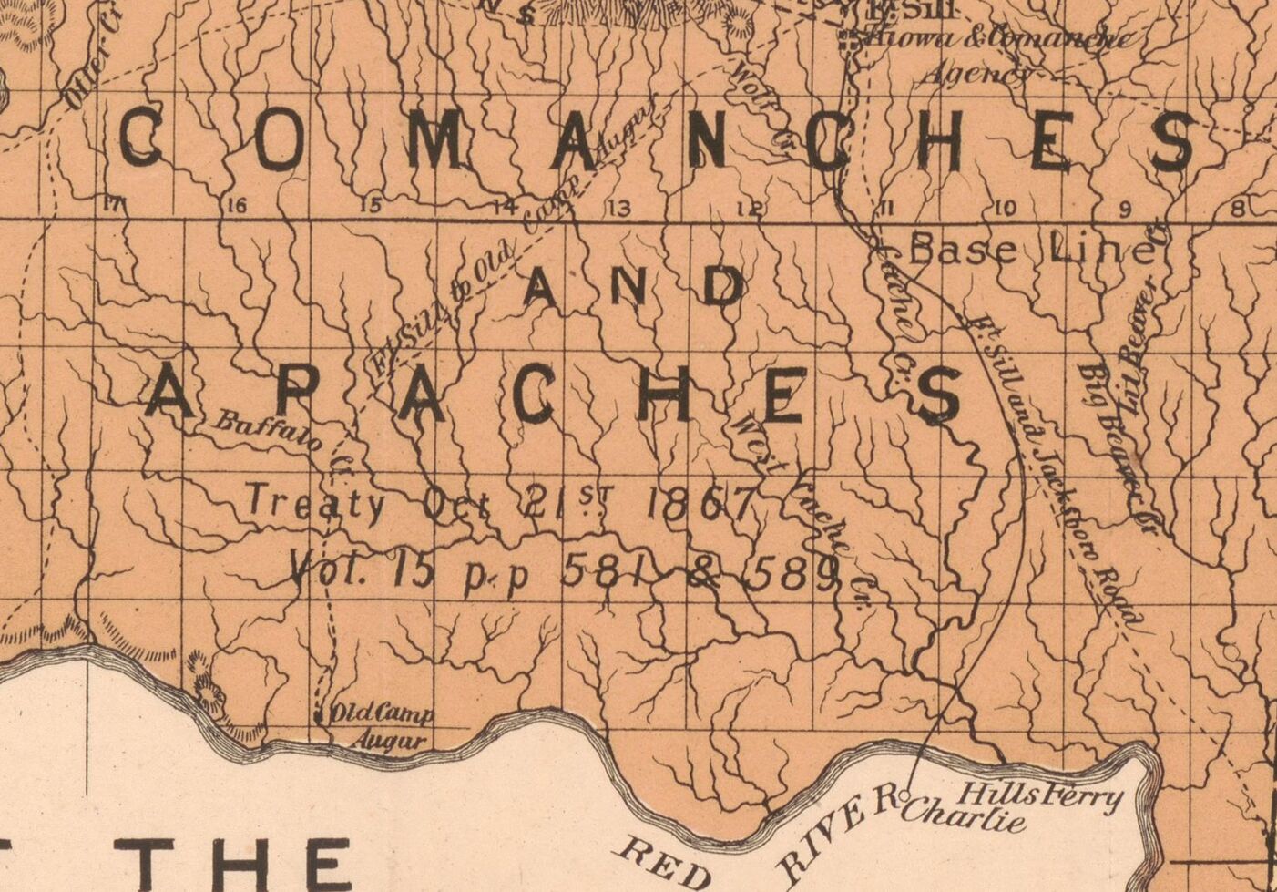
So, the United States saw an opportunity. In the Adams-Onis Treaty of 1819, negotiated by John Quincy Adams, Secretary of State in the James Monroe administration, the United States promised Spain that it would not interfere with Spain’s claims below the Red River, but that the Great Bend area would become part of the United States. To mark this boundary, an imaginary line was drawn south from the Red River to the 32nd parallel along the 18th Meridian (from Washington, D.C., not Greenwich). This is now known as the Index Line. In addition, the U.S. gave Spain some much-needed cash and Spain gave away Florida. Spain asserted its claims on today’s Texas, New Mexico, Arizona, Utah, Nevada, parts of Colorado, and California.

But that’s not all!

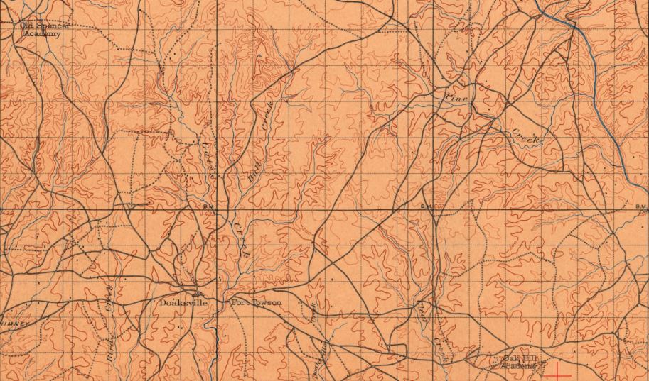
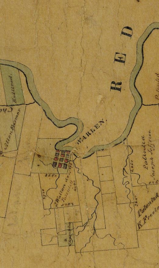
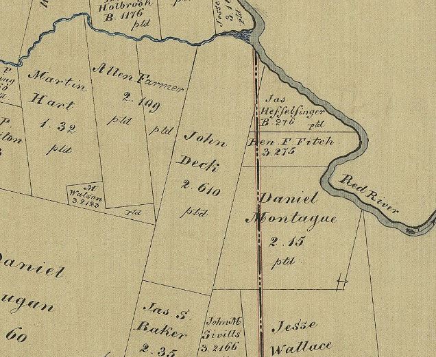
Around 1821, Spanish Texas became Mexican Texas. The Anglos who filibustered south of the Red River beyond the Index Line showed dual loyalties: they claimed to be Mexicans who needed military assistance when the U.S. tried to impose taxes, and they claimed to be U.S. citizens needing military assistance when Mexico allowed displaced native tribes to settle in the region. This is why the “proposed boundary of Arkansas” on this 1835 map extends to the 19th Meridian and 33rd parallel… the Anglos at Jonesboro (in today’s Red River County, TX) and south of Pecan Point (today’s McCurtain County, OK) claimed this portion of Mexico for the U.S. once Fort Towson (today’s Choctaw County, OK) was established in 1824.

Published in: on July 22, 2020 at 2:01 am  Comments (2)  
Tags: , ,

False raid

This wire sent from Denison in April of 1873 reported an Indian raid that never happened. This article was cited widely in multiple papers, too. This is a snip from the Kasnas Democrat (Oswego, KS).

Once again, old newspapers reveal stories that hide more insidious events. I was researching something unrelated when I stumbled upon a reference to a “train with government supplies for Fort Griffin… captured by Indians on Cole Creek sixty-five miles from Denison.” (Denison is in Grayson County, TX and Fort Griffin is in Shackleford County, TX).

This raid took place in April of 1873 and is referenced in several newspapers. All of the newspapers reproduce a wire that the Denison Democrat sent to St. Louis. The text of the telegram was found in the April 25, 1873 issue of the New York Herald, May 2 1873 Kansas Democrat, and April 25 1873 Republican Banner from Nashville, TN. In some newspapers, the report was filed under “Indian and Mexican Troubles.”

This raid, of course, is not about the infamous Warren Wagon Train Massacre of 1871. The “train” does not refer to a locomotive but rather, a mule-cart outfit. The supplies consisted of food stuffs, materials, and sometimes, weaponry.

Frank Leslie’s Illustrated Newspaper from New York also relayed the report of a raid on Cole Creek, which turned out to be false, and like the other newspaper, did not issue a retraction.

While a number of raids on wagon trains took place in this period – with most of the blame laid at the feet of random “Indians” – I haven’t been able to point to the site of this particular one. The only Cole Creek I know of is northeast of Electra (Wichita County, Texas). There are other Cole Creeks but not in North Texas, at least to my knowledge. And none of the Cole Creeks are “sixty-five miles” from Denison.

The only Cole Creek in North Texas or southern Indian Territory is in Wichita County near Electra, which lies about 180 miles away from Denison (and not 65 miles). US Bureau of Soils.

I asked readers on my Facebook group about this raid – perhaps they knew of a place that I wasn’t familiar with?

One of my readers, MC Toyer, mentioned the “Indian Papers of Texas and the Southwest.” In this collection of letters and documents, Indian agents explained that rumors of raids spread often in localities and newspapers without evidence. This supposed raid at Cole Creek, for example, was a complete fabrication. Toyer cited a letter from J M Haworth, Kiowa and Comanche Agency, IT to Cyrus Beede, Chief Clerk of the Central Indian Superintendency, May 8, 1873: “The report of the killing of surveyors as sent by Shirley turns out to be false, also a report telegraphed from Texas recently of the killing of four men and capture of a train. I have learned since I came here that a large majority of the Indian reports are fabrications manufactured out of whole cloth.”

The newspapers never retracted this false information, either.

These kinds of rumors created fear and mistrust where none were warranted and further eroded any possibility of co-existence between the white elites and the Native tribes. So this got me to thinking. I wonder how many of the violent episodes between “settlers” and Native Americans actually happened in North Texas?

Stay tuned to see what I turn up, if anything!

Questions this blog post might generate:

What might the purpose have been for a newspaper to report a raid, and then not further report that the information was untrue?

Since the location of this false raid was also faulty, the person who wrote the wire was most likely no a local. What benefit(s) would a person who issues a false report about an Indian raid seek?

In what way(s) does a false report like this perpetuate racism?

An academy for Freedmen

Oak Hill Industrial School in 1905 was established for freed people, formerly enslaved by the Choctaws, near today’s Valliant in Indian Territory.

Per the 1866 treaties signed after the Civil War, the Choctaw and Chickasaw nations were supposed to provide education to the people it had formerly enslaved. The Chickasaw Nation never did this, but the Choctaw Nation’s historic affiliation with Presbyterian missionaries garnered collaborations to build schools to serve African American youths. Along the old road between Ultima Thule and Doaksville near the Red River (today’s Valliant, McCurtain County, Oklahoma) Oak Hill Industrial Academy was established in 1869 with funding by the Presbyterian Church for the education of freed people in the Choctaw Nation. The first terms as a real boarding school occurred nearly two decades later, in 1886, after the Choctaw Nation enrolled freed people as citizens in 1880 and African Americans demanded schools of their own as they were denied access to the academies at Spencerville, Armstrong, and Wheelock.

Initially, Oak Hill students met in the old log cabin of Robin Clark, a Choctaw Freedman, where studies focused on religious instruction and basic literacy (Clark’s log cabin had been initially built by Chief Leflore in the 1850s). Gradually, buildings and land were donated to the school by native black teachers.

This 1901 USGS map shows Oak Hill Academy, a prominent feature east of Fort Towson along the old military road.

The Presbytery recruited Anglo teachers, many from Pennsylvania, to expand instruction in academics. The main focus continued to be on mechanical education in farming and home economics. While this sounds practical, it was also a paternalistic denial of African American advancement. Though in his 1914 book about the academy, Robert Elliot Flickinger recognized discrimination and mistreatment of African Americans, he also wrote that one of the school’s goals was to “prevent sloth.”

Oak Hill Industrial Academy became a self-sufficient farming complex in which the crops, honey, and milk raised by the students helped to sustain the institution. In 1912, the school was re-named to “The Alice Lee Elliot Memorial School” to honor the wife of a donor from Indiana. As one of very few high schools for African American students in southeastern Oklahoma, the Oak Hill Industrial Academy/ Alice Lee Elliot Memorial School closed in 1936 when the Choctaw Nation moved to a public but nonetheless segregated school system.

Today, a historical marker at Valliant cemetery commemorates the academy, but there are no physical reminders of the school left on the surface.

Read more about Oak Hill Academy in this very informative blog post: http://african-nativeamerican.blogspot.com/2011/02/remembering-oak-hill-academy-for.html

Students pose in front of Oak Hill buildings. The large buildings in the front served as dormitories and classrooms. On the left sits the academy chapel. Between the chapel and dormitory is a two story, log cabin; perhaps this is Robin Clark’s cabin, a Choctaw Freedman who used his home (the home of former chief LeFlore) as a make-shift school when Oak Hill was first opened as a school for freed people.

Questions this blog post might generate:

Choctaw Freedmen donated buildings and taught the first classes at Oak Hill. However, when the Presbyterian Church begins to manage the school, white teachers were recruited from far away (and most lasted only a year) and hired instead. What happened to the black teachers? Why did the church do this?

How does the state purpose of the school —to prevent sloth —reflect racism?

Why did the Choctaws segregate black students from native students? White students, with special permission, could attend academies like Armstrong and Wheelock, but not black students.

Camp no longer

Camp Augur LOC

Map of the Comanche and Apache nation in Oklahoma Territory in 1889, noting the location of “Old Camp Augur” on the Red River.

Camp Augur in today’s Tillman County, Oklahoma was founded in 1871 to protect the tribes impacted by the Medicine Lodge Treaty of 1867. The camp never became a permanent post. Its role was to ensure that the peaceful bands of the Comanches and Apaches stayed safe from hostile Texans, and that peaceful Texans were safe from hostile Comanche and Apache bands.

Much of the hostility perpetrated by Texans stemmed from land squatting – meaning, Texans entered Oklahoma Territory and tried to stake rights on lands that were designated for the Wichita, Kiowa, Comanche and Apache reservations. These actions became especially egregious in the mid 1880s, after the last of the tribe’s war bands were defeated in the Red River Wars in 1875. The “hostilities” by the bands included unauthorized hunting; it was considered illegal for Indians to hunt bison or even to own a gun.

Named after General Christopher Columbus Augur (1821-1898) while he served as the commandant of the Department of Texas during the Reconstruction Period, the camp closed by the late 1880s because by then, non-natives continued to encroach on the lands and enjoyed U.S. congressional backing. Congress authorized that over 2 million acres of reservation land be set aside for land sales (aka “land rushes”). The Kiowa tribe sued because in doing so, Congress had violated the Medicine Lodge Treaty of 1867. In 1903, the Supreme Court sided with the non-natives in Lone Wolf v. Hitchcock… writing that the U.S. Congress had the power to “abrogate provisions of any Indian treaty.”

Monumental historical impacts and far-reaching consequences can be discerned just by reading maps.

Published in: on May 11, 2020 at 3:26 am  Leave a Comment  
Tags: , , ,

Old friends

Sanger depot

The depot from Sanger (Denton County, Texas) was moved to Tioga (Grayson County) and now has a second life as an antique store.

Drove to Tioga (Grayson County, TX) yesterday and visited several places in Gene Autry’s home town: Clark’s Outpost (re-opened after a bad fire – best BBQ in North Texas), the Tioga calaboose, and the Sanger (Denton County, TX) depot!

Sanger’s Santa Fe depot is now the Cedar Depot, home to antiques, architectural salvage items, and a wood shop.

Whenever I visit old depots, I zero in on their graffiti. Passengers and workers idled their time away by either burning or writing their initials, dates, and artwork into the boards. Sanger’s depot has some fine examples, though you have to look past the wares to see it.

The owner, Andy, showed me around. One item he found of most interest was a tree stump from Pilot Point, with a farm implement grown into the wood. Andy told me that in New York, where he’s from, placing farm implements in trees became a tradition for young men drafted into war. When they came back, they took the implement out. If they didn’t come back, the farm implement stayed… he wondered if this was also a Texas tradition. I’d never heard of the practice around these parts, but that doesn’t mean it didn’t exist.

A cell complex from the old, demolished Denton County jail, which was state-of-the-art in the 1920s, is for sale at the depot. These are the same cells that I discovered at an estate sale earlier this year. I think the jail cells would make a great addition to the historic park in Denton.

Sanger grafitti

If you look inside the freight section of old depots (which aren’t wallpapered but simple boards), you’ll often find graffiti, like this inscription from 1922.

Sanger stump

A farm implement inside a cedar log may indicate that the person who placed it there never came back from war. At least, that was the tradition in New York state; unsure if that was a tradition in Texas. This log was inside the Cedar Depot (nee Sanger Depot) in Tioga, (Grayson County, TX). The log came from Pilot Point (Denton County, TX).

Sanger Denton cells for sale

The cells from the old Denton County Jail (1891), which I once found at an estate sale, are for sale at the Depot (at least as of this writing, April 2020).

Tioga calaboose 2

Another jail – Tioga’s old calaboose – sits in a park in Tioga.

Published in: on April 2, 2020 at 12:09 am  Comments (1)  
Tags: , ,

Jail bait

hardy accomodation

Inside the jail cells in a field in rural Denton County.

I love estate sales, where I look for old correspondence and photographs. I’m also nosy and estate sales let me find some awesome places… like today.

I live in Denton County (Texas) that once had a two story, bricked county jail. Built in 1891, it was demolished a few decades ago. I met the son of the warden’s family just the other day, and he mentioned that somewhere, out in a field, were two cells from the old building.

Well, whadya know… I came across the cells today at the estate sale. The property consisted of all sorts of machinery, barns full of scraps, and this beauty.

I took tons of pictures and my poor husband got nervous. He saw me eyeing the price ($1250). “We have no where to put it,” he kept saying, in a small but determined voice. “And how would we move it?” He had flashbacks to the time I bought 500 Thurber paversand drove them home in our F150 (which broke the struts. Oops).

I said cryptically, “Where there’s a will, there’s a way” but alas, it was not meant to be.

Luckily for Mr. RedRiverHistorian, the cells were bought by a person who wants to use them to decorate a restaurant. I don’t think that worked out, because I recently saw the cells for sale at the old Sanger Depot, which is an antique store in Tioga, Texas. But I have pictures!!!!!

jail 1891 built 1980s demo

The Denton County jail before its demolition in 1981.

cell

Trees and brambles anchored the remaining cells onto the prairie.

Freddi

Some denizens of the jail from the 1940s left their mark.

Published in: on April 1, 2020 at 11:50 pm  Comments (1)  
Tags: , ,

Rural education

Farmeres Industrial School main principal cottage school bell

Farmers Improvement College near Ladonia, Fannin County, Texas. (Baylor University)

In 1906, a group of civic leaders put their collective minds to work and opened the Farmers Improvement College on donated land. This well-funded college, along the Sulphur River and Santa Fe Railroad just southeast of Ladonia, Fannin County, Texas, served African American girls and boys from grades six to twelve and was designed as an agricultural school grounded in the sciences. Male students learned farming and female students studied home economics. Families paid room, board, and tuition to secure their children a place. The school closed in 1946.

Like most historic schools in the Red River Valley, the many buildings that made up the Farmers Industrial College (aka Farmers Industrial School, or F. I. S.) no longer exist. The school was still on the county’s soil map from 1940, but nothing remains of the site now except for a simple granite marker.

Farmers College 1946 Soil Map of Fannin County portal

1946 soil map from the Texas GLO shows the Farmers’ College just southeast of Ladonia.

Farmers College location today

An aerial satellite map of the Farmers College’s location shows no buildings remaining.

Published in: on March 10, 2020 at 1:36 am  Leave a Comment  
Tags: , ,

Town, erased

SAMSUNG CAMERA PICTURES

Beautiful tombstone of Ella Colbert, Wife of Holmes Colbert (1869 to 1896), Willis Cemetery, Marshall County, Oklahoma. Due to the imagery, I wonder if she died in childbirth?

The Willis Cemetery sits just off US 377 north of Lake Texoma in Marshall County, Oklahoma. This is the only remain of the former town of Willis. Willis is an old town; it was first settled by a Chickasaw family in the 1840s, where they operated a ferry crossing the Red River. By the 1920s, the town of Willis was fairly large, with eight stores and a preacher who had a side business as a casket maker (an entrepreneurial chap!).

In the mid-1940s, the Dension Dam was built to provide water and hydro-electric power to southern Oklahoma and northern Texas. Because of the many rivers that fed the Red from Oklahoma, Oklahomans lost three times as much land as the Texans did. The community of Willis lost its ferry, its downtown… pretty much everything that made the town, a town.

1905 map snip of Marshall County with Willis OK LOC

Willis is written in all caps in this 1905 map of the territory, indicating its relative prominence. Notice that two ferries operated in close proximity to each other by Willis, Marshall County, Oklahoma. (Library of Congress)

1948 OK highway map official OK DOT

A 1948 Oklahoma highway department map doesn’t even show Willis, Marshall County, Oklahoma anymore – its vital link between Oklahoma and Texas was erased by the lake.

SAMSUNG CAMERA PICTURES

Hand carved tombstone in the Willis Cemetery (Marshall County, Oklahoma) reads: Rachal Junetia Looney / Borned Nov 19, 1925/ Died Sept 12, 1930.

Published in: on February 25, 2020 at 2:54 am  Leave a Comment  
Tags: , ,

A visit to Brushy Mound

BM 2

A feature map of Cooke County, Texas, reveals the Brushy Mound community, also known as Brushy Mountain (Texas General Land Office).

The cemetery and former church (?) or school (?) site in Brushy Mound, Cooke County, Texas (identified as Brushy Mountain on an 1888 map) are located in some of the most beautiful countryside along the Red River Valley.

Two above-ground remnants indicate that a quite substantial building was once here – a stone base and a very large (but flooded) storm shelter. However, the only reference to a “Brushy” school that I’ve found in cursory search is in Montague County. It was mentioned in volume 1 of the Texas Teachers Journal (1888).

Brushy Mound sits at the base of steep hills and rolling prairie northeast of St. Jo (Montague County). Lots of wineries to try out in this area once your history thirst is quenched, too!

BM 1

A storm shelter on top of Brushy Mound, that sits just east of the cemetery’s limits, hints that at one point, there must have been a fairly large structure near the cemetery.

BM 4

Another hint of the now-gone Brushy Mound church and/or school building. The actual structure may have been a combined Masonic Lodge/school/church.

BM 3

The cemetery is all that’s left of Brushy Mound, which sits in the high, scenic hills between northern Cooke and Montague Counties in Texas.


Published in: on February 17, 2020 at 5:33 pm  Leave a Comment  
Tags: ,

Warren once was

Warren on Red River 1841 GLO

Warren (Fannin County, Texas) sat along the Red River during the Republic of Texas (1836-1845) and early statehood years (1845-1860).

Warren, Texas was once the seat of Fannin County. The town originally consisted of a private wooden fort and trading post along the Red River, erected by Abel Warren around 1836. Daniel Montague received the original land grant surrounding the trading post and opened up a store at the site after the Texas Revolution.

At one point, Warren was connected via a primitive road to Coffee’s Station, Lexington, and Raleigh, all early trading posts along the Red River in north Texas. Today, whatever is left of the road is used by tractors in pastures.

Warren on Montague Land 1885 county line straddle GLO

Daniel Montague, one of the more sinister characters in Texas history, owned the land patent where Warren would grow into a town surrounding his trading post.

Daniel Montague is the namesake of Montague County, though he never resided there – his last residence was in Marysville in northwestern Cooke County. In Texas history, Montague was known as an Indian fighter as well as a staunch Confederate. During the Republic of Texas period, he led at least two brutal raids on bands of the Wichita tribe, which started local warfare between the Euro-American and Native American settlements. He also served as the jury foreman during the trials of alleged Union sympathizers in Cooke County. He and the jury ultimately sentenced 41 men to hang for opposing the Confederate draft.

Warren, as you may have guessed by now, is no longer a town. By 1843, the settlement surrounding Fort Inglish (also a private trading post), had replaced it as a county seat due to its more central location. The new county seat, originally called Bois d’Arc, became known as Bonham. Apparently, the old courthouse in Warren was moved to Bonham in the 1920s but never re-built… and now, I have to wonder where it is.

Warren near Ambrose Google Maps

Today, Warren lies under silt and sand between Ambrose and the Choctaw Bayou in the extreme northwestern part of Fannin County … and into the extreme northeastern part of Grayson County.

Published in: on December 2, 2019 at 5:59 pm  Leave a Comment  
Tags: , , ,